


SpyMeSat app for iPhone and iPad
4.4 (
1024 ratings )
Utilities
Education
Developer: Orbit Logic
Free
Current version: 4.1.6, last update: 6 months agoFirst release : 18 Sep 2013
App size: 148.32 Mb
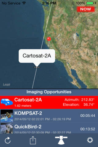
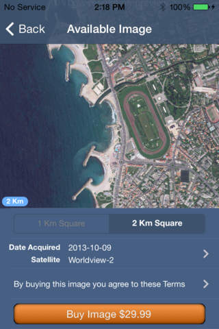
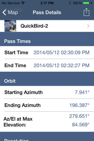
Introducing SpyMeSat, the first app to provide the public with full awareness and access to commercial and unclassified imaging satellites. SpyMeSat provides real-time imaging satellite overflight notifications, on-demand access to recent high resolution satellite images, and the ability to request an imaging satellite take a new picture just for you! SpyMeSat provides easy access to satellite imagery to the public for the first time and makes satellite imagery more readily available to industry and government.
Features of the SpyMeSat mobile app are protected by U.S. Patents 9344994, 9779301, 10817561, 10853410, and 11113330
Pros and cons of SpyMeSat app for iPhone and iPad
SpyMeSat app good for
Great app to learn about imaging satellites ... and discount pricing for recent satellite imagery . . . and now the ability to task a satellite to take a new image . . . Wow !!!
I can task multiple Satellite to take my picture?! This app is awesome! It is cool watching the different imaging satellites in the app come and go over my location. I love being able to move my location and also find archived satellite imagery for purchase at a great price and if I dont see a recent satellite image well I can take one myself! Cool app. Customer service is also great! I contacted the provider with a question and got a fast response from a person not a computer automated response.
Pretty cool. My sons school is also ordering a satellite image. Theyre going to have all the children outside for the picture. I was also gonna get a pic of my wedding location and frame it for my wife. A nice addition to our " we" wall.
Update:
The imagery purchase option is surprising. The FAQs are helpful.
Overall: Bit of fun for fans of space/spacecraft and anyone trying to get an entry into the guiness book of world record that ends with "can be seen from space"
Keeps getting better! Order new and archived imagery from vendors! Plan your outdoor activities around satellite passes so they cant observe you. (Great for the tin-foil hat crowd.)
Free version: cant beat the price!
Some bad moments
With its anemic non-responsive user interface involving the incredibly long wait time for "Calculating Satellite Passes" over and over again, this instantly feels like a complete waste of money. I mean, seriously, there is no real-world use for this app outside of general nerdiness, and then it even behaves badly.
The only purpose of this app is to sell satellite photos for $$.
This is most useless app I downloaded so far.
Its doesnt provide even option of one good free shot . You need subscription.
UI is not user friendly and intuitive (looks like one of those typical free apps) .
Highly NOT recommended unless you just want to fill some empty space on iPhone (even for that is too small lol) .
I dont understand what this app is for and keeps annoying me that some satellite is passing by
Takes like 15-30 minutes to calculate satellite trajectories. Then usually crashes half way through. Had high hopes.
The fundamental premise of this application is cute - find out when a satellite "could" be spying on you. Mind you, these are only commercial/civil satellites, not real spy satellites. The app description clearly tells you this - so dont expect to find out about true spy satellites from the NRO. I say "could" because all of these satellites have a very small field of view for their camera (or SAR). Just because the satellite has a clear line of sight to your location does not mean that it will actually point its camera in that direction. Again, not a criticism, since the app description explains this.
The problem is that there are a number of apps already available that can tell you when ANY satellite is visible to you (has a clear line of sight, in other words - it is over the horizon). So what does SpyMeSat gain you that these other apps dont have? Very little. SpyMeSat limits its database to only imaging/SAR satellites, so in essence it provides a "filer" for this particular type of satellite. It does add a brief description and picture of each satellite. The one other unique feature the app has is the ability to filter satellites by type (EO vs SAR) and resolution of payload. But fundamentally that is it. So for $1.99 you get fewer satellites than most other apps and few additional features.
The other disappointing area is its map display. The map centers around your geographic location (can’t be panned or zoomed, though strangely it can be temporarily rotated). Ground tracks are only displayed when satellites are about to be visible at your location, so most of the time, the map is devoid of any ground tracks. There is no way to see where any of the satellites are at any given location. Finally, the way to select your location is extremely ineffective. You can have the app use your current location, but you have to go into a menu two levels deep. Alternatively you can “drop a pin” on the Apple map interface to select the location of interest. There is no way to type in lat/lon or look up a city in a database.
All in all, not worth your time or money. I know this company’s “real” products. They produce state-of-the-art planning software that is actually used to control some of the commercial imaging satellites like GeoEye or WorldView. But their foray into phone apps is a miss.